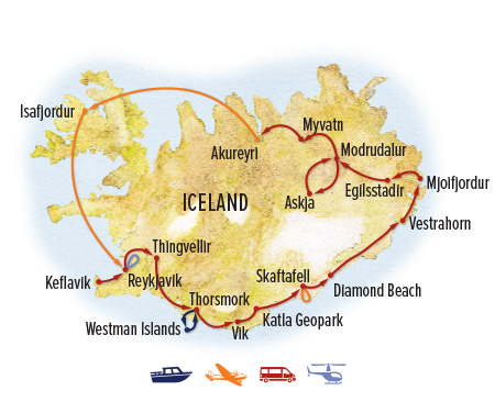
2024 Itinerary
A note about our schedule: In most cases, we will rise later and stay out very late, to capitalize on the often ethereal evening light (and less people!). Since Iceland lies near the Arctic Circle, the days are long, and it doesn't get truly dark at high summer. The light can be magic, and we plan our long days to take advantage of it.
Day 1: Keflavik, Iceland / Reykjavik
Arrive at Keflavik International Airport where you are met on arrival and transferred to our hotel in Reykjavik, about a 45-minute drive. This evening, join our Expedition Leader for a welcome dinner at a local restaurant, with an orientation to all the photography adventures that lie ahead in this geological wonderland.
Day 2: Private Helicopter Photo Tour / Thingvellir National Park / Strokkur Geyser / Waterfalls
Our adventures begin with an exhilarating aerial introduction: a two-hour “Fire and Ice” helicopter tour. Flying over Glymur, the highest waterfall in Iceland, we make our first landing near Thorisjokull Glacier for close-up views of the ice cap. Our flight continues over Thingvellir National Park, offering a riveting vantage on the continental drift of the Eurasian and North American tectonic plates that is only fully visible from above. Our second landing is in the Hengill geothermal area, a remote valley that’s only accessible via helicopter or a long hike, where we walk among a dynamic landscape of hot springs and boiling mud pots.
Much of Iceland is powered by renewable geothermal energy, and we stop for a view of a geothermal power plant. Then it’s on to Thingvellir National Park for an on-the-ground perspective on Iceland’s geological origins. Here on the Mid-Atlantic Ridge, the very epicenter of where the Icelandic landscape is forming, we can actually see fissures where the earth’s crust is separating. Thingvellir is also where Iceland was founded politically, when Norse settlers formed the world’s first parliament in 930 AD. On this site, 30 ruling chiefs met to discuss law and order on the island and to create a government. In the park, we hike to views of Oxarafoss waterfall and Iceland’s largest lake, Thingvallavatn.
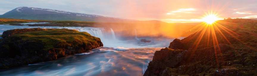
Later today, photograph highlights on the famous Golden Circle route, after most day trippers have left. Bruarfoss is one of Iceland’s most beautiful waterfalls, where dozens of cascading streams from the Bruara River fall in a semi-circular pattern, converging once more in the rushing blue river below. After dinner, we visit Strokkur, Iceland’s most active geyser, erupting about every 10 minutes. Then, in the golden hour light, continue to powerful Gulfoss, formed during the last ice age when glacial runoff carved out a deep canyon, creating a series of drops over which the Hvita River plunges. Finally, we arrive at our hotel on the South Coast to spend the next two nights.
Day 3: Thorsmork Valley—Private Super Jeep Tour
After a leisurely morning to rest up, head out on a full-day Super Jeep tour into Thorsmork, mythical homeland of the Norse thunder god, Thor. This remote valley in Iceland’s southern highlands rests among three ice caps, including that of Eyjafjallajökull, which released powerful glacial floods during the volcano’s 2010 eruption. We travel in specially adapted 4x4 vehicles built to navigate the rough terrain and river crossings, in awe of the primal landscape surrounding us. Stark peaks rise in every direction, rent with deep gorges and braided rivers coursing down from the icefields on high. In contrast to the dark rock summits, lime green moss covers the lower slopes like soft velvet. Keep your camera ready in case we spy an Arctic fox, Iceland’s only native mammal. Sightings aren't frequent, but we might see one. A picnic dinner in the field allows us to remain out during the best light, when the northern summer sun begins its slow, late descent and the peaks are illuminated by its golden rays.
Day 4: Westman Islands / Private RIB Safari / Seabird Photography
Depart late this morning for a rare inclusion on any Iceland itinerary: the remote Westman Islands. From Landeyjahofn, we board a ferry for the 45-minute crossing to the main island of Heimaey. The Westman Islands—Vestmannaeyjar in Icelandic—were formed between 10,000 and 20,000 years ago from submarine eruptions. The land here remains very young, active and dynamic, shaped afresh with the 1973 eruption of Eldfell volcano that forced the entire Westman population to evacuate to the mainland via the islands’ fishing fleet. Heimaey was covered in ash and lava as the eruption continued for months, but eventually the stalwart islanders returned to dig out their homes and settle anew.
After lunch on arrival, we board a sturdy high-speed RIB boat for a 2-hour marine photo safari. Cruise to several of the islands beyond Heimaey, anticipating sightings of whales and seals along the way. Later this evening we walk among colonies of nesting seabirds, which breed here in prolific numbers. Photo opportunities are outstanding, and we may see razorbill, guillemot, Atlantic puffin, northern fulmar, shearwater, storm petrel and a variety of gulls, including the great skua and black-legged kittiwake. Northern gannets are the top draw, with huge colonies of thousands nesting here. Birds thrive in the Westmans in tremendous numbers due to a lack of predators on the islands—most notably Arctic fox.
Day 5: Westman Islands / Vik—South Coast Photography
More Westmans discovery is in store on a morning walk atop lava flows from Eldfell Volcano. Witness plant life regenerating after the eruption 50 years ago, as lichen, mosses and more reclaim the scoured land. On a scenic drive, we make stops at viewpoints to photograph mainland Iceland and Eyjafjallajökull volcano in the distance. After a late lunch in town, board an afternoon ferry back to the South Coast and continue to our hotel in Vik, an area known for its volcanic black sand beaches and some of Iceland’s most spectacular waterfalls. Once we drop our bags, we head out to photograph Dyrholaey lighthouse and Reynisdrangar Rocks. Legend holds that this trio of columnar basalt sea stacks was formed after two trolls were out fishing in a three-masted ship. When the trolls did not return to their cave before sunrise, they and their vessel turned into needles of stone, since trolls cannot tolerate daylight. After dinner, golden hour beckons, and we head out to photograph Vik’s iconic 1929 wooden church, painted white with a red roof and steeple—an appealing foreground subject against a backdrop of green hills and coastal cliffs. Reynisfjara black sand beach is also a captivating subject, with the waves and shoreline bathed in the glow of sunset.
Day 6: Katla Geopark / Skaftafell Private Flightseeing / Glacier Lagoons / Diamond Beach
Explore more fascinating geological features on Iceland’s south coast as we investigate the dynamic relationship between fire and ice, examining the largest glacial outwash plane in the world. Katla UNESCO Global Geopark contains roughly 9% of Iceland’s total landmass, encompassing massive glaciers and active volcanoes that have shaped the land for millennia, including the powerful eruptions of Eyjafjallajokull in 2010 and Grimsvotn in 2011. The geopark also holds glacial rivers, lakes, meadows of purple lupine, black sand beaches, waterfalls, vast lava fields, and caverns, including Hjorleifshofdi Cave, also known as the “Yoda Cave” after it was featured in the Star Wars film Rogue One.
This afternoon, get an aerial perspective on some of Iceland's most dramatic scenery from a private fixed-wing plane flight over the Skaftafell region of Vatnajokull National Park. This one-hour low-altitude adventure reveals an artistic landscape, with intriguing patterns, contrasts and colors for creative imagery. Photograph the plain of Skeidararsandur, an expanse of black sand and ash sliced by braided glacial rivers that resemble an intricate network of veins. Capture striking shots of the jagged expanse of Skeidararjokull Glacier, draining off Vatnajokull, Iceland’s largest ice cap. Later, we have extended time at two glacier lagoons—Fjallsarlon and Jokulsarlon—to photograph the glittering icebergs floating atop the meltwater lakes. After dinner, as golden hour arrives once again, we visit Diamond Beach, a favorite spot for photographers, where icebergs wash up on shore to create a sparkling contrast with the volcanic black sand. Seals also frequent the beach, and orcas are sometimes seen offshore.
Day 7: Coastal Photography—Stokksnes & Vestrahorn / East Fjords / Egilsstadir
Today marks a transition in our itinerary, moving from Iceland’s youngest and most dynamic landscapes along the active rift zone toward older regions along the east coast. Near Hofn, we’ll shoot bucolic scenes of sheep grazing in lush pastures and striking coastal rock formations. The Stokksnes Peninsula is full of enticing subjects, from beaches of jet-black sand to 10-foot-high sand dunes covered in bright green beach grass, and the ragged profile of Vestrahorn, one of Iceland’s most stark and stunning mountains. The sheer-sided massif is comprised mostly of rare gabbro rock, a plutonic magma nearly 11 million years old. We also photograph evocative Estrahorn, its jagged profile surveying a wild black sand beach on the southeast corner of Iceland.
We follow the coast into the little-visited East Fjords, which has some of the oldest rock in Iceland, with layer upon layer of basalt from ancient eruptions slowly carved away by 2.5 million years of successive ice ages. The expansive coastal plain transitions to classic U-shaped glacial valleys flanked by weathered basalt mountains. The ocean is always close as the road winds along the fjord-riven coast, unveiling rocky coves and picturesque fishing villages. The tiny town of Djupivogur hugs the mouth of narrow Berufjordur Fjord, where we may see whales, seals and dolphins. After dinner in Breiddalsvik, we capitalize on the evening light as we meander our way through the peaceful, less-traveled Breiddalur Valley, with stops along the way to photograph burbling creeks, lakes and striking mountains. A short walk leads to Flogufoss, a hidden waterfall deep in the valley that flows beneath a picturesque natural bridge. Then, we drive across a mountain pass and drop into the glacial valley of Lagarfljot, continuing to Egilstaddir, East Iceland’s largest town, where we check in to our hotel for two nights.
Day 8: East Fjords—Mjoifjordur / Borgarfjordur Eystri—Puffin Photography
Our focus for the first half of the day is one of the most photogenic of the East Fjords, the slender finger of Mjoifjordur, which means "narrow fjord." Carved out by successive ice ages and protected from the elements along the outer coast, the water is often calm as glass, making for beautiful reflection photography. We occasionally spot whales in the fjord as well. This is one of the most remote destinations in Iceland, accessed by a road that is open for only about four months a year, when it is snow-free. The steep, winding gravel road that descends to the sea extends to the end of the 11-mile fjord. Mjoifjordur’s setting at the head of the fjord is stunning, surrounded by an amphitheater of waterfalls. A highlight is Klifbrekkufossar, a seven-step cascade that terraces down through a rugged chasm carpeted with green vegetation. A trail hugs the side of the waterfall, allowing access to varied angles and closer views.
Continue to Borgarfjordur Eystri, a fjord that is reputedly home to one of numerous “elfin communities” that thrive in Icelandic mythology. The fjord takes its name from the Icelandic elf-queen, Alfaborg, who is said to live nearby. Here we find one of Iceland’s largest Atlantic puffin colonies, and we spend several hours among them this afternoon on a puffin photography intensive. A boardwalk weaving through the colony allows easy access, and since the puffins are accustomed to human presence, we are able to get exceptionally close shots. Return to Egilsstadir for a second night.
Day 9: Lagarflojt Valley / Modrudalur
Travel inland today from Egilsstadir for an in-depth exploration of scenic Lagarflojt Valley. We stop for photos of Lagarflojt Lake, where local lore holds that a sea monster inhabits its waters. We are surrounded by an evocative wild, rural landscape, offering opportunities to photograph Icelandic horses, rarely seen waterfalls, and impressive canyons. Climbing into the highlands, we follow Iceland's original Highway 1 over two remote passes and through a rare tract of Icelandic forest to reach Modrudalur. This is one of the oldest farms in Iceland, with evidence of its presence since the original settlement by the Vikings. The site was an important crossroads where two historic cross-country trails intersected, and its location is referenced in the famous Sagas that date to the 10th and 11th centuries. Modrudalur is also the highest inhabited place in Iceland, at 1,539 feet above sea level. We spend the next two nights here at Fjalladyrd, a hospitable family-run farm. This unique guesthouse allows us easy access to Askja volcano for our 4x4 adventure tomorrow.
Day 10: Askja Crater Private Super Jeep Tour
After a quiet morning of photography via short walks near the farm, we set out in Super Jeeps after lunch for a thrilling photography adventure to Askja caldera. These large SUVs have been modified with huge tires and extra shock absorption to provide a more comfortable ride over off-road terrain, allowing deeper access into Iceland’s central highlands. We ascend to the crater rim on foot to photograph the massive Askja caldera, formed when the volcano erupted in 1875. Lake Askja, which fills part of the depression, is one of the deepest lakes in Iceland, at nearly 700 feet. The 5-mile-wide caldera contains several overlapping craters with active volcanoes beneath, including Viti, which warms a sulphuric blue-green crater lake. The stark, open landscape, essentially an arctic desert covered in pumice and ash, is reminiscent of the moon, and U.S. astronauts conducted moon landing exercises here in the 1960s. Following a picnic dinner in the field, Following a picnic dinner, we drive back to Modrudalur during the golden hour, stopping to photograph lava flows of varied ages, and magnificent mountain scenery illuminated in the magical highland light.
Day 11: Dettifoss & Selfoss / Lake Myvatn / Hverarond / Akureyri
Photograph mighty Dettifoss, Europe’s largest waterfall by volume and the most powerful in Iceland. This thundering curtain of water, churning spray into the sky, is 330 feet wide and 150 high, fed by the giant Vatnajokull Glacier, which spawns the Jokulsa a Fjllum River. Dettifoss is contained inside a massive canyon carved out by ancient glacial outwash floods, where four times the volume of the Amazon River once tore through this landscape. We frequently see rainbows over the falls, which make for dramatic photos. We also stop at Selfoss, a striking U-shaped wall of rushing cataracts fed by the same river originating in Vatnajokull.
Continue to Lake Myvatn, located in the rift zone of the North American and Eurasian tectonic plates. The lake was formed during a massive eruption 2,300 years ago and is still a site of geothermal activity, with lava flows coming most recently from the 1984 eruption of Krafla volcano. Numerous lava formations are found in and around the shallow lake, and we photograph the pseudocraters of Skutustadir on a short hike. These phenomena are formed when lava flows over wet ground, pushing it down and trapping steam. As pressure mounts, steam explosions create these fascinating "false craters." One of the premier birdwatching areas in the world, Lake Myvatn’s marshes provide habitat for huge numbers of migratory birds in summer. More than 115 species have been seen at the lake, including 15 species of nesting ducks, horned grebe, great northern diver, common loon, red-throated loon, whooper swan, Barrow's goldeneye, and many more seasonal visitors. Nearby, photograph the striking turquoise lake filling Krafla Viti Crater, 6 miles in diameter and surrounded by stark lava fields as far as the eye can see. More of Iceland's simmering subterranean energy is on display at Hverarond, hissing with steam vents, bubbling mud pots and pungent sulphur. After dinner in Myvatn, drive west to photograph Godafoss, one of Iceland’s most beautiful waterfalls, which originates deep in the highlands. Shaped like a crescent, it drops 40 feet over a sheer volcanic cliff. As golden hour arrives, we drive along Eyjafjordur, one of the longest fjords in Iceland, to Akureyri.
Day 12: Akureyri—Whale Watching / Chartered Flight to Isafjordur
After a morning of whale watching in Akureyri, connect with our chartered flight to Isafjordur, with scenic views of Iceland's fjord-indented coastline and glacier-carved interior en route. Originally settled in the 9th century, Isafjordur became a trading post for foreign merchants in the 16th century and today is the main town in the remote Westfjords in far-northwest Iceland. The sheer isolation of the Westfjords region has kept it off the traditional tourist circuit, and we traverse it in depth over the next three days, adjusting our exact itinerary for weather and local conditions.
Day 13: Westfjords—Private Svalvogar Circle Super Jeep Tour
Explore the Westfjords' wild hinterlands on an all-day Super Jeep tour around the Svalvogar Circle route, stopping frequently for photos, walks and a scenic picnic en route. This loop around the Fjallaskagi Peninsula, honed of stratified basalt, is heralded as one of the most stunning roads in all of Iceland. At Onundarfjordur, observe rich birdlife in the marshlands and shallow estuary at the head of the fjord. Continue to the village of Thingeyri and beyond, transitioning to dirt track where high-clearance 4x4 vehicles are essential for negotiating this rugged terrain. As we ascend the pass that marks the highest point on the route, we have views of the highest mountains in the Westfjords. Keep an eye out for Arctic fox, and look for pieces of petrified trees sticking out of the rocks alongside the narrow road—remnants of a forest that flourished in a much warmer climate millions of years ago.
Day 14: Exploring the Westfjords
Via mini bus, we survey more of the Westfjords region with the utmost in flexibility to capitalize on the best photo opportunities. We pass through many small fishing villages, making frequent stops to photograph quintessentially Westfjords communities and landscapes. A highlight is Bolafjell Lookout on the site of an old military radar station, where a viewing platform juts out from a 2,100-foot-high vertical cliff, offering an unimpeded panorama of the sheer stacked rock and frigid fjord far below. A pathway along the summit offers a less vertiginous view. In the golden light of evening, photograph Dynjandi Waterfall, the largest in the Westfjords—a wide, lacy curtain that tumbles down a rugged rock face in tiers, like a flowing bridal veil.
Day 15: Whale Watching / Vigur Island / Fly to Reykjavik
Look for humpback and minke whales on a private RIB marine safari this morning. In this little-visited region, we can expect much solitude on the water as we ply the fjords in a high-speed rigid inflatable boat. Later this afternoon, visit Vigur Island via a private boat ride from Isafjordur. This small outpost is home to thousands of seabirds including a colony of 100,000 Atlantic puffins. If you didn't get your fill of puffin photos earlier, you will today, and we may see them carrying fish back to their nests, protected holes hollowed out of a steep, grassy cliff. Other seabirds include Arctic terns, black guillemot and eider ducks, the source of precious down from which the island’s sole resident family makes its living, collecting feathers in the spring and summer and cleaning and drying them during the winter. Just a handful of people inhabit the tiny island, which is a conservation zone, and we join them for lunch in their home. You can also send a postcard here from Europe’s smallest post office. Our maritime adventure continues as we ply the intricate fjord system, searching for humpback and minke whales. Return to Isafjordur for an early farewell dinner, then catch our evening flight back to Reykjavik for a final night.
Please Note: Activities in the Westfjords may take place on days or times that are different from what is listed in this itinerary, depending on local schedules, weather conditions, etc.
Day 16: Reykjavik / Keflavik / Depart
After breakfast, a transfer to Keflavik International Airport is included to meet departing flights.
An important note about flightseeing: Please be aware that all flightseeing opportunities are weather-dependent. Should weather and visibility conditions force the cancellation of any flights, we will substitute alternate photography-focused activities.
Day 1: Keflavik, Iceland / Reykjavik
Arrive at Keflavik International Airport where you are met on arrival and transferred to our hotel in Reykjavik, about a 45-minute drive. This evening, join our Expedition Leader for a welcome dinner at a local restaurant, with an orientation to all the photography adventures that lie ahead in this geological wonderland.
Day 2: Private Helicopter Photo Tour / Thingvellir National Park / Strokkur Geyser / Waterfalls
Our adventures begin with an exhilarating aerial introduction: a two-hour “Fire and Ice” helicopter tour. Flying over Glymur, the highest waterfall in Iceland, we make our first landing near Thorisjokull Glacier for close-up views of the ice cap. Our flight continues over Thingvellir National Park, offering a riveting vantage on the continental drift of the Eurasian and North American tectonic plates that is only fully visible from above. Our second landing is in the Hengill geothermal area, a remote valley that’s only accessible via helicopter or a long hike, where we walk among a dynamic landscape of hot springs and boiling mud pots.
Much of Iceland is powered by renewable geothermal energy, and we stop for a view of a geothermal power plant. Then it’s on to Thingvellir National Park for an on-the-ground perspective on Iceland’s geological origins. Here on the Mid-Atlantic Ridge, the very epicenter of where the Icelandic landscape is forming, we can actually see fissures where the earth’s crust is separating. Thingvellir is also where Iceland was founded politically, when Norse settlers formed the world’s first parliament in 930 AD. On this site, 30 ruling chiefs met to discuss law and order on the island and to create a government. In the park, we hike to views of Oxarafoss waterfall and Iceland’s largest lake, Thingvallavatn.
Later today, photograph highlights on the famous Golden Circle route, after most day trippers have left. Bruarfoss is one of Iceland’s most beautiful waterfalls, where dozens of cascading streams from the Bruara River fall in a semi-circular pattern, converging once more in the rushing blue river below. After dinner, we visit Strokkur, Iceland’s most active geyser, erupting about every 10 minutes. Then, in the golden hour light, continue to powerful Gulfoss, formed during the last ice age when glacial runoff carved out a deep canyon, creating a series of drops over which the Hvita River plunges. Finally, we arrive at our hotel on the South Coast to spend the next two nights.
Day 3: Thorsmork Valley—Private Super Jeep Tour
After a leisurely morning to rest up, head out on a full-day Super Jeep tour into Thorsmork, mythical homeland of the Norse thunder god, Thor. This remote valley in Iceland’s southern highlands rests among three ice caps, including that of Eyjafjallajökull, which released powerful glacial floods during the volcano’s 2010 eruption. We travel in specially adapted 4x4 vehicles built to navigate the rough terrain and river crossings, in awe of the primal landscape surrounding us. Stark peaks rise in every direction, rent with deep gorges and braided rivers coursing down from the icefields on high. In contrast to the dark rock summits, lime green moss covers the lower slopes like soft velvet. Keep your camera ready in case we spy an Arctic fox, Iceland’s only native mammal. Sightings aren't frequent, but we might see one. A picnic dinner in the field allows us to remain out during the best light, when the northern summer sun begins its slow, late descent and the peaks are illuminated by its golden rays.
Day 4: Westman Islands / Private RIB Safari / Seabird Photography
Depart late this morning for a rare inclusion on any Iceland itinerary: the remote Westman Islands. From Landeyjahofn, we board a ferry for the 45-minute crossing to the main island of Heimaey. The Westman Islands—Vestmannaeyjar in Icelandic—were formed between 10,000 and 20,000 years ago from submarine eruptions. The land here remains very young, active and dynamic, shaped afresh with the 1973 eruption of Eldfell volcano that forced the entire Westman population to evacuate to the mainland via the islands’ fishing fleet. Heimaey was covered in ash and lava as the eruption continued for months, but eventually the stalwart islanders returned to dig out their homes and settle anew.
After lunch on arrival, we board a sturdy high-speed RIB boat for a 2-hour marine photo safari. Cruise to several of the islands beyond Heimaey, anticipating sightings of whales and seals along the way. Later this evening we walk among colonies of nesting seabirds, which breed here in prolific numbers. Photo opportunities are outstanding, and we may see razorbill, guillemot, Atlantic puffin, northern fulmar, shearwater, storm petrel and a variety of gulls, including the great skua and black-legged kittiwake. Northern gannets are the top draw, with huge colonies of thousands nesting here. Birds thrive in the Westmans in tremendous numbers due to a lack of predators on the islands—most notably Arctic fox.
Day 5: Westman Islands / Vik—South Coast Photography
More Westmans discovery is in store on a morning walk atop lava flows from Eldfell Volcano. Witness plant life regenerating after the eruption 50 years ago, as lichen, mosses and more reclaim the scoured land. On a scenic drive, we make stops at viewpoints to photograph mainland Iceland and Eyjafjallajökull volcano in the distance. After a late lunch in town, board an afternoon ferry back to the South Coast and continue to our hotel in Vik, an area known for its volcanic black sand beaches and some of Iceland’s most spectacular waterfalls. Once we drop our bags, we head out to photograph Dyrholaey lighthouse and Reynisdrangar Rocks. Legend holds that this trio of columnar basalt sea stacks was formed after two trolls were out fishing in a three-masted ship. When the trolls did not return to their cave before sunrise, they and their vessel turned into needles of stone, since trolls cannot tolerate daylight. After dinner, golden hour beckons, and we head out to photograph Vik’s iconic 1929 wooden church, painted white with a red roof and steeple—an appealing foreground subject against a backdrop of green hills and coastal cliffs. Reynisfjara black sand beach is also a captivating subject, with the waves and shoreline bathed in the glow of sunset.
Day 6: Katla Geopark / Skaftafell Private Flightseeing / Glacier Lagoons / Diamond Beach
Explore more fascinating geological features on Iceland’s south coast as we investigate the dynamic relationship between fire and ice, examining the largest glacial outwash plane in the world. Katla UNESCO Global Geopark contains roughly 9% of Iceland’s total landmass, encompassing massive glaciers and active volcanoes that have shaped the land for millennia, including the powerful eruptions of Eyjafjallajokull in 2010 and Grimsvotn in 2011. The geopark also holds glacial rivers, lakes, meadows of purple lupine, black sand beaches, waterfalls, vast lava fields, and caverns, including Hjorleifshofdi Cave, also known as the “Yoda Cave” after it was featured in the Star Wars film Rogue One.
This afternoon, get an aerial perspective on some of Iceland's most dramatic scenery from a private fixed-wing plane flight over the Skaftafell region of Vatnajokull National Park. This one-hour low-altitude adventure reveals an artistic landscape, with intriguing patterns, contrasts and colors for creative imagery. Photograph the plain of Skeidararsandur, an expanse of black sand and ash sliced by braided glacial rivers that resemble an intricate network of veins. Capture striking shots of the jagged expanse of Skeidararjokull Glacier, draining off Vatnajokull, Iceland’s largest ice cap. Later, we have extended time at two glacier lagoons—Fjallsarlon and Jokulsarlon—to photograph the glittering icebergs floating atop the meltwater lakes. After dinner, as golden hour arrives once again, we visit Diamond Beach, a favorite spot for photographers, where icebergs wash up on shore to create a sparkling contrast with the volcanic black sand. Seals also frequent the beach, and orcas are sometimes seen offshore.
Day 7: Coastal Photography—Stokksnes & Vestrahorn / East Fjords / Egilsstadir
Today marks a transition in our itinerary, moving from Iceland’s youngest and most dynamic landscapes along the active rift zone toward older regions along the east coast. Near Hofn, we’ll shoot bucolic scenes of sheep grazing in lush pastures and striking coastal rock formations. The Stokksnes Peninsula is full of enticing subjects, from beaches of jet-black sand to 10-foot-high sand dunes covered in bright green beach grass, and the ragged profile of Vestrahorn, one of Iceland’s most stark and stunning mountains. The sheer-sided massif is comprised mostly of rare gabbro rock, a plutonic magma nearly 11 million years old. We also photograph evocative Estrahorn, its jagged profile surveying a wild black sand beach on the southeast corner of Iceland.
We follow the coast into the little-visited East Fjords, which has some of the oldest rock in Iceland, with layer upon layer of basalt from ancient eruptions slowly carved away by 2.5 million years of successive ice ages. The expansive coastal plain transitions to classic U-shaped glacial valleys flanked by weathered basalt mountains. The ocean is always close as the road winds along the fjord-riven coast, unveiling rocky coves and picturesque fishing villages. The tiny town of Djupivogur hugs the mouth of narrow Berufjordur Fjord, where we may see whales, seals and dolphins. After dinner in Breiddalsvik, we capitalize on the evening light as we meander our way through the peaceful, less-traveled Breiddalur Valley, with stops along the way to photograph burbling creeks, lakes and striking mountains. A short walk leads to Flogufoss, a hidden waterfall deep in the valley that flows beneath a picturesque natural bridge. Then, we drive across a mountain pass and drop into the glacial valley of Lagarfljot, continuing to Egilstaddir, East Iceland’s largest town, where we check in to our hotel for two nights.
Day 8: East Fjords—Mjoifjordur / Borgarfjordur Eystri—Puffin Photography
Our focus for the first half of the day is one of the most photogenic of the East Fjords, the slender finger of Mjoifjordur, which means "narrow fjord." Carved out by successive ice ages and protected from the elements along the outer coast, the water is often calm as glass, making for beautiful reflection photography. We occasionally spot whales in the fjord as well. This is one of the most remote destinations in Iceland, accessed by a road that is open for only about four months a year, when it is snow-free. The steep, winding gravel road that descends to the sea extends to the end of the 11-mile fjord. Mjoifjordur’s setting at the head of the fjord is stunning, surrounded by an amphitheater of waterfalls. A highlight is Klifbrekkufossar, a seven-step cascade that terraces down through a rugged chasm carpeted with green vegetation. A trail hugs the side of the waterfall, allowing access to varied angles and closer views.
Continue to Borgarfjordur Eystri, a fjord that is reputedly home to one of numerous “elfin communities” that thrive in Icelandic mythology. The fjord takes its name from the Icelandic elf-queen, Alfaborg, who is said to live nearby. Here we find one of Iceland’s largest Atlantic puffin colonies, and we spend several hours among them this afternoon on a puffin photography intensive. A boardwalk weaving through the colony allows easy access, and since the puffins are accustomed to human presence, we are able to get exceptionally close shots. Return to Egilsstadir for a second night.
Day 9: Lagarflojt Valley / Modrudalur
Travel inland today from Egilsstadir for an in-depth exploration of scenic Lagarflojt Valley. We stop for photos of Lagarflojt Lake, where local lore holds that a sea monster inhabits its waters. We are surrounded by an evocative wild, rural landscape, offering opportunities to photograph Icelandic horses, rarely seen waterfalls, and impressive canyons. Climbing into the highlands, we follow Iceland's original Highway 1 over two remote passes and through a rare tract of Icelandic forest to reach Modrudalur. This is one of the oldest farms in Iceland, with evidence of its presence since the original settlement by the Vikings. The site was an important crossroads where two historic cross-country trails intersected, and its location is referenced in the famous Sagas that date to the 10th and 11th centuries. Modrudalur is also the highest inhabited place in Iceland, at 1,539 feet above sea level. We spend the next two nights here at Fjalladyrd, a hospitable family-run farm. This unique guesthouse allows us easy access to Askja volcano for our 4x4 adventure tomorrow.
Day 10: Askja Crater Private Super Jeep Tour
After a quiet morning of photography via short walks near the farm, we set out in Super Jeeps after lunch for a thrilling photography adventure to Askja caldera. These large SUVs have been modified with huge tires and extra shock absorption to provide a more comfortable ride over off-road terrain, allowing deeper access into Iceland’s central highlands. We ascend to the crater rim on foot to photograph the massive Askja caldera, formed when the volcano erupted in 1875. Lake Askja, which fills part of the depression, is one of the deepest lakes in Iceland, at nearly 700 feet. The 5-mile-wide caldera contains several overlapping craters with active volcanoes beneath, including Viti, which warms a sulphuric blue-green crater lake. The stark, open landscape, essentially an arctic desert covered in pumice and ash, is reminiscent of the moon, and U.S. astronauts conducted moon landing exercises here in the 1960s. Following a picnic dinner in the field, Following a picnic dinner, we drive back to Modrudalur during the golden hour, stopping to photograph lava flows of varied ages, and magnificent mountain scenery illuminated in the magical highland light.
Day 11: Dettifoss & Selfoss / Lake Myvatn / Hverarond / Akureyri
Photograph mighty Dettifoss, Europe’s largest waterfall by volume and the most powerful in Iceland. This thundering curtain of water, churning spray into the sky, is 330 feet wide and 150 high, fed by the giant Vatnajokull Glacier, which spawns the Jokulsa a Fjllum River. Dettifoss is contained inside a massive canyon carved out by ancient glacial outwash floods, where four times the volume of the Amazon River once tore through this landscape. We frequently see rainbows over the falls, which make for dramatic photos. We also stop at Selfoss, a striking U-shaped wall of rushing cataracts fed by the same river originating in Vatnajokull.
Continue to Lake Myvatn, located in the rift zone of the North American and Eurasian tectonic plates. The lake was formed during a massive eruption 2,300 years ago and is still a site of geothermal activity, with lava flows coming most recently from the 1984 eruption of Krafla volcano. Numerous lava formations are found in and around the shallow lake, and we photograph the pseudocraters of Skutustadir on a short hike. These phenomena are formed when lava flows over wet ground, pushing it down and trapping steam. As pressure mounts, steam explosions create these fascinating "false craters." One of the premier birdwatching areas in the world, Lake Myvatn’s marshes provide habitat for huge numbers of migratory birds in summer. More than 115 species have been seen at the lake, including 15 species of nesting ducks, horned grebe, great northern diver, common loon, red-throated loon, whooper swan, Barrow's goldeneye, and many more seasonal visitors. Nearby, photograph the striking turquoise lake filling Krafla Viti Crater, 6 miles in diameter and surrounded by stark lava fields as far as the eye can see. More of Iceland's simmering subterranean energy is on display at Hverarond, hissing with steam vents, bubbling mud pots and pungent sulphur. After dinner in Myvatn, drive west to photograph Godafoss, one of Iceland’s most beautiful waterfalls, which originates deep in the highlands. Shaped like a crescent, it drops 40 feet over a sheer volcanic cliff. As golden hour arrives, we drive along Eyjafjordur, one of the longest fjords in Iceland, to Akureyri.
Day 12: Akureyri—Whale Watching / Chartered Flight to Isafjordur
After a morning of whale watching in Akureyri, connect with our chartered flight to Isafjordur, with scenic views of Iceland's fjord-indented coastline and glacier-carved interior en route. Originally settled in the 9th century, Isafjordur became a trading post for foreign merchants in the 16th century and today is the main town in the remote Westfjords in far-northwest Iceland. The sheer isolation of the Westfjords region has kept it off the traditional tourist circuit, and we traverse it in depth over the next three days, adjusting our exact itinerary for weather and local conditions.
Day 13: Westfjords—Private Svalvogar Circle Super Jeep Tour
Explore the Westfjords' wild hinterlands on an all-day Super Jeep tour around the Svalvogar Circle route, stopping frequently for photos, walks and a scenic picnic en route. This loop around the Fjallaskagi Peninsula, honed of stratified basalt, is heralded as one of the most stunning roads in all of Iceland. At Onundarfjordur, observe rich birdlife in the marshlands and shallow estuary at the head of the fjord. Continue to the village of Thingeyri and beyond, transitioning to dirt track where high-clearance 4x4 vehicles are essential for negotiating this rugged terrain. As we ascend the pass that marks the highest point on the route, we have views of the highest mountains in the Westfjords. Keep an eye out for Arctic fox, and look for pieces of petrified trees sticking out of the rocks alongside the narrow road—remnants of a forest that flourished in a much warmer climate millions of years ago.
Day 14: Exploring the Westfjords
Via mini bus, we survey more of the Westfjords region with the utmost in flexibility to capitalize on the best photo opportunities. We pass through many small fishing villages, making frequent stops to photograph quintessentially Westfjords communities and landscapes. A highlight is Bolafjell Lookout on the site of an old military radar station, where a viewing platform juts out from a 2,100-foot-high vertical cliff, offering an unimpeded panorama of the sheer stacked rock and frigid fjord far below. A pathway along the summit offers a less vertiginous view. In the golden light of evening, photograph Dynjandi Waterfall, the largest in the Westfjords—a wide, lacy curtain that tumbles down a rugged rock face in tiers, like a flowing bridal veil.
Day 15: Whale Watching / Vigur Island / Fly to Reykjavik
Look for humpback and minke whales on a private RIB marine safari this morning. In this little-visited region, we can expect much solitude on the water as we ply the fjords in a high-speed rigid inflatable boat. Later this afternoon, visit Vigur Island via a private boat ride from Isafjordur. This small outpost is home to thousands of seabirds including a colony of 100,000 Atlantic puffins. If you didn't get your fill of puffin photos earlier, you will today, and we may see them carrying fish back to their nests, protected holes hollowed out of a steep, grassy cliff. Other seabirds include Arctic terns, black guillemot and eider ducks, the source of precious down from which the island’s sole resident family makes its living, collecting feathers in the spring and summer and cleaning and drying them during the winter. Just a handful of people inhabit the tiny island, which is a conservation zone, and we join them for lunch in their home. You can also send a postcard here from Europe’s smallest post office. Our maritime adventure continues as we ply the intricate fjord system, searching for humpback and minke whales. Return to Isafjordur for an early farewell dinner, then catch our evening flight back to Reykjavik for a final night.
Please Note: Activities in the Westfjords may take place on days or times that are different from what is listed in this itinerary, depending on local schedules, weather conditions, etc.
Day 16: Reykjavik / Keflavik / Depart
After breakfast, a transfer to Keflavik International Airport is included to meet departing flights.
An important note about flightseeing: Please be aware that all flightseeing opportunities are weather-dependent. Should weather and visibility conditions force the cancellation of any flights, we will substitute alternate photography-focused activities.
Physical Rating: Moderate
Repeater Layout :
vertical