

Itinerary
Itinerary
Day 1: Arrive in Reykjavik before your journey into Iceland’s wild landscapes
Explore Iceland’s compact, walkable capital
Join your Expedition Leader for a welcome dinner and preview of the adventure ahead
Arrive at Keflavik International Airport where you are met on arrival and transferred to our hotel in Reykjavik, about a 45-minute drive. If you arrive early, you may store your bags at our conveniently located hotel while you explore this compact, walkable city on your own. This evening, join our Expedition Leader for a welcome dinner at a local restaurant, with an orientation to all the adventures that lie ahead in this geological wonderland.

Day 2: View puffins, explore a seal beach and take a 4x4 ride to a glacier
Cruise to Akurey Island to view nesting puffins
Watch harbor seals hauled out along Ytri Tunga Beach
Take a private 4x4 up Snaefellsjokull Glacier Volcano
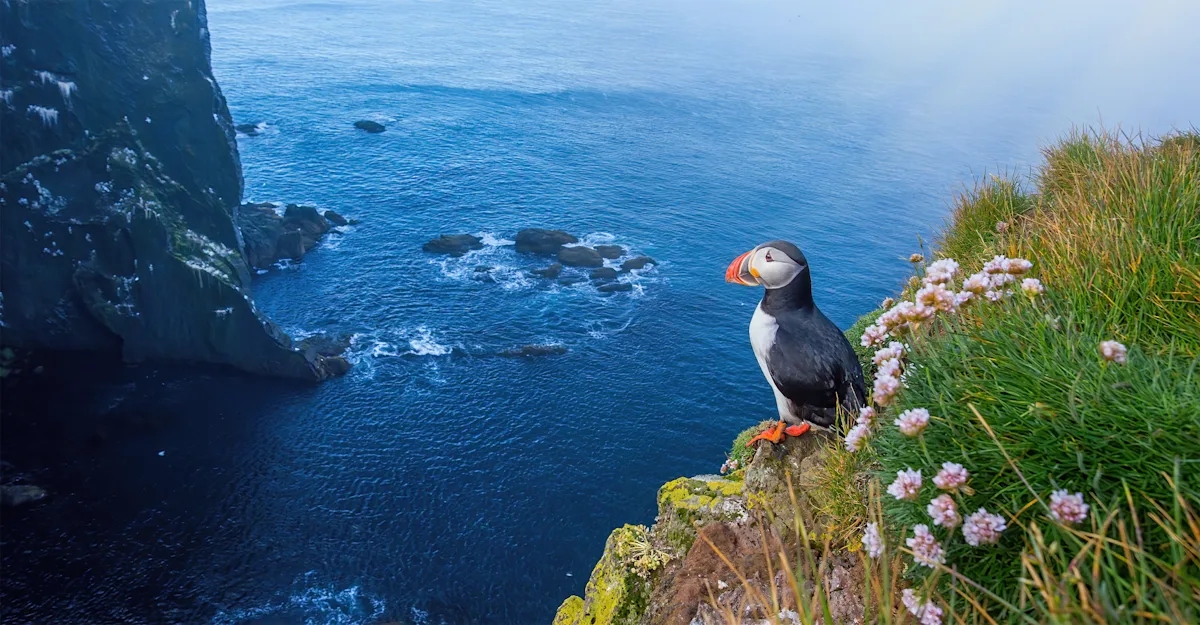
Start the morning with a private cruise to a puffin colony on the island of Akurey. The charming Atlantic puffin, with its clown-like visage, is Iceland’s most famous bird, and the country is home to more than 60% of the world’s population, with 8–10 million in total and 30,000 nesting just offshore from Reykjavik. From Reykjavik’s old harbor, we sail 15 minutes to reach the rocky island, offering close-up views of these whimsical seabirds nesting on the cliffs.
Once we’re back on shore, we drive to the Snaefellsnes Peninsula. Often called “Iceland in miniature” due to the diversity of natural features found here, this prominent outthrust on Iceland's west coast holds glaciers, mountains, stratovolcanoes, lava fields, waterfalls, wild beaches and marine wildlife. We spend two nights based in the remote coastal hamlet of Budir, giving us ample time to explore the wealth of wild sights.
Ytri Tunga Beach is one of the best places in Iceland to see harbor seals, often hauled out on rocks just offshore. Once extensively hunted for their meat, fat for oil, and waterproof pelts, today they are appreciated by most Icelanders for their place in nature. After lunch in Hellnar, we walk from this traditional fishing village to another, bound for Arnastapi. The scenic trail along the shoreline passes lava cliffs and columnar basalt formations on one side, with mountains and Snaesfellsjokull Glacier on the other.
A much closer view of the glacier is in store this afternoon as we travel by 4x4 up the flanks of Snaefellsjokull. a 700,000-year-old stratovolcano rising nearly 5,000 feet above the sea. Identified by its conical shape, Snaefellsjokull is an imposing sight, formed when layers of lava and ash from successive eruptions build up around the vent, creating steep, sloping sides. Snaefellsjokull is also known as a glacier volcano, totally covered in ice, including its 650-foot-deep summit crater. Its last eruption was in the 3rd century. We get right next to its frozen flanks, climbing from the coast on a scenic drive over a mountain pass with dramatic views of the ice-cloaked volcano before us. On a clear day the views are stupendous, and we may be able to see all the way to Reykjavik. Snaefellsjokull is Iceland’s most famous volcano, and many believe it to be one of the world’s main centers of mystical energy—it holds the title role in in Jules Verne’s 1864 novel Journey to the Center of the Earth, who posited that subterranean tubes inside the volcano led deep inside the planet.

Day 3: Explore the volcanic landscapes of Snaefellsjokull National Park
Ride Icelandic horses on a black sand beach
Walk the rugged coastline past basalt pinnacles and bird cliffs
Visit Svodufoss below the ice-capped volcano
Start the day with a short hike to see Bjarnarfoss, one of Iceland's most striking waterfalls. At 262 feet high, it falls in a two-tiered plume, plunging off a vertical wall of basalt columns cloaked in bright green vegetation. Tucked into a valley and backdropped by tall mountains, it makes for a photogenic scene, with white spray contrasting against the dark basalt cliff. Then enjoy a gentle horseback ride on the golden sands of Hraunlandarif Beach. This private experience is a special opportunity to get to know the famous Icelandic horse breed—unique to this island nation and fiercely protected: no horses from outside are permitted into Iceland, to keep the strain pure.
Next, we're off to Snaefellsjokull National Park for more scenic exploration. The park is named for the stratovolcano that domiantes it, and we admire dramatic views at every turn. Our tour of the park includes a dramatic coastal walk from Londrangar to Malarrif, passing the towering Londrangar basalt rock pinnacles, Thufubjarg bird cliff teeming with kittiwakes, guillemots and northern fulmars, and the tall white stone tower of Malarrif Lighthouse. We’ll also walk on the black sands of Djupalonssandur Beach and peer into Saxholl Crater, accessed via a gradual staircase to the rim. The magnificent view over the collapsed core encompasses sprawling lava fields that surround it, and when skies are clear, you can see all the way to the Atlantic Ocean.
Our last stop is Svodufoss, one of Iceland’s most photogenic yet less-visited waterfalls. The broad, powerful cascade sits in front of Snaefellsjokull Glacier, and on a clear day, we can see it and the ice cap together, making for striking photos. Although it’s just 32 feet high, Svodufoss’s clean drop over a columnar basalt cliff into the Laxa River below is a magnificent sight.
Day 4: View Iceland's most famous mountain & tour the Eider Center
Photograph Kirkjufell reflected beside Kirkjufellsfoss
Explore the fishing village of Stykkisholmur
Learn about eider down production
Kirkjufell, or “Church Mountain,” is the most photographed geographic profile in Iceland, and we get here early in the morning before most other visitors arrive. Standing alone and visible for great distances, Kirkjufell’s symmetrical sides rise to a rounded cone top. Though it is just 1,519 feet high, its isolation makes it appear taller, since it is the most prominent landmark for miles around. A lake at the base offers a perfect mirror image of the peak on a clear, calm day. The classic image of Kirkjufell includes multi-plumed Kirkjufellsfoss, the series of waterfalls pouring off a basalt cliff in the foreground.
Next, take a walk through the fishing village of Stykkisholmur on the far northern point of the Snaefellsnes Peninsula. The picturesque town was originally a trading post in the 16th century, but its history goes back farther as one of Iceland’s earliest settlements, mentioned in the Sagas, one of the great early works of Icelandic literature. We’ll also view the lighthouse on Sugandisey Island, connected to the town by a bridge. Sykkisholmur sits on Breidafjordur Bay, the largest eiderduck area in the world, and we learn about down production at the Icelandic Eider Center. Through photographs, films and educational exhibits, view nesting, down collection and cleaning, and historic and contemporary methods for producing eiderdown.
This afternoon, we drive to Husafell, an isolated community on the edge of Iceland’s vast, uninhabited interior. Set in the valley carved by Langjokull, Iceland’s second-largest glacier, Husafell is one of Iceland’s hidden secrets—an ancient Viking settlement that today is a place to encounter fire and ice away from crowds.

Day 5: Descend into a lava cave before soaking in geothermal baths
Explore Vidgelmir, Iceland’s largest lava cave
See Hraunfossar and the churning waters of Barnafoss
Soak in the geothermal Canyon Baths beneath glacier-clad peaks
Vidgelmir is Iceland’s largest lava cave, and we take a private tour deep into its subterranean tunnels and caverns to witness firsthand the powerful geological forces that have sculpted this land. Volcanic eruptions have shaped not only the physical environment but also the culture of Iceland, and we hear myths and stories, along with science, as we explore this otherworldly terrain beneath the Earth's surface. Also nearby are two of Iceland’s many stupendous waterfalls. Hraunfossar, which means “lava waterfalls,” is actually a wide cataract—a collection of countless creeks and cascades streaming over a lava platform. Just above is Barnafoss, a torrent of foaming white turbulence blasting beneath a lava arch.
This afternoon, another experience is in store that captures the essence of Iceland: a private tour and soak in the Canyon Baths. The geothermal pools enjoy a grand view of the surrounding canyon, mountains and glaciers. Constructed from locally sourced, natural materials like flagstone from the canyon floor, the baths are hot-spring fed pools designed to blend into the environment using the age-old methods that created Snorralaug, a heritage-site pool dating back to the 10th century. The bathhouse is made from salvaged timbers from the area, and even the hooks in the changing room are repurposed horseshoes from a nearby family farm. Following this relaxing escape, return to our stylish hotel and anticipate an outstanding dinner featuring seasonal local fare.
Day 6: Cross Iceland’s volcanic Highlands by custom 4x4
Travel through the rugged Kaldidalur Valley
Stand between two tectonic plates at Thingvellir National Park
Hike among the colorful peaks and geothermal valleys of Kerlingarfjoll
Today we head deep into Iceland’s vast and wild interior, making our way into the Central Highlands. Our route first takes us through the Kaldidalur Valley via a remote road over Iceland’s second-highest pass, cresting to an elevation of 2,385 feet. Our own custom 4x4 mini bus with giant all-terrain tires has no trouble navigating the rugged gravel roads, which are off-limits to less capable vehicles. The drive is spectacular, with views of multiple glaciers, including Langjokull—the “long glacier”—which covers 360 square miles. We'll also see the shield volcano of Skjaldbreidur, formed around 9,000 years ago in an eruption that also created the basin of Thingvellir.
En route we stop at Thingvellir National Park, a UNESCO World Heritage Site, for an on-the-ground perspective on Iceland’s geological and political origins. Here on the Mid-Atlantic Ridge, the very epicenter of where the Icelandic landscape is forming, we can actually see fissures where the earth’s crust is separating. Thingvellir is also where Iceland was founded politically, when Norse settlers formed the world’s first parliament in 930 AD. On this site, 30 ruling chiefs met to discuss law and order on the island and to create a government. The Althing, an open-air assembly representing the whole of Iceland, is the oldest surviving parliament in the world, though today it meets in Reykjavik. This afternoon we reach Highland Base at Kerlingjarfjoll, a remote luxury outpost that is our jumping-off point for exploring the mountain wilderness around us. Take an introductory guided walk this afternoon, surveying the rugged peaks that rise in every direction.

Day 7: Hike among rhyolite peaks and steaming geothermal valleys
Trek past obsidian ridges, mineral-streaked mountains and active geothermal features
Soak in a natural mineral-rich hot spring
Learn more about Iceland's "fire and ice" geological forces
From our isolated base deep in the Highlands, we have easy access to the rugged terrain around us, and there's no more intimate way to explore it than on foot. Today is devoted to hiking amid these fantastical peaks, which rise in an array of shapes, forms and colors, the rock palette tinted by rhyolite and obsidian. Green alpine moss and lichen add occasional bright accents among the jagged ridges, volcanic summits, geothermal areas, and deep valleys. At times, the stark setting is evocative of a moonscape. After a day of exploration, do as the locals do: retreat to a steaming hot spring for a rejuvenating soak in the mineral-laden waters.
Day 8: See Iceland's most famous geyser erupt & gaze into Kerid Crater
Witness Strokkur Geyser and an array of simmering features at Geysir Geothermal Area
Admire the vivid colors of Kerid Crater's walls and the turquoise lake at the bottom
Enjoy a farewell dinner with your Expedition Leader and fellow travelers
Spend the morning exploring more of the rugged, colorful landscape around Kerlingjarfjoll, then make a scenic half-day drive back to Keflavik. En route we stop at the famous Geysir Geothermal Area featuring bubbling mineral springs, steaming fumaroles, mud pots and the active Strokkur geyser that erupts every 10 minutes or so, blasting hot spray as high as 100 feet into the air. The English word "geyser" is derived from the Icelandic word "geysir," which means gusher.
We also stop at Kerid Crater, a 6,500-year-old caldera filled with a lake that is one of Iceland’s most visually stunning features. Unlike most craters formed by violent explosions, Kerid was created when the volcano's magma chamber emptied and the cone collapsed inward. The caldera, ringed by steep slopes, features vivid red iron-rich rock and green moss that contrast sharply with the bright blue-green water at the bottom.
Ultimately, we reach Keflavik, where we check into our hotel conveniently located near the airport. This evening, gather for a farewell dinner, with a chance to reflect on the full gamut of adventures we've enjoyed over the past week.

Day 9: Depart Reykjavik after exploring the land of fire and ice
Transfer to the airport for homeward flights
Enjoy a final breakfast as our Iceland adventure comes to a close. A transfer is included from the hotel to Keflavik International Airport to meet departing flights.

