


By Nat Hab Expedition Leader Eddy Savage
Iceland is well known around the world as the land of fire and ice and is one of the rawest places I have had the pleasure of exploring. Situated in the North Atlantic and isolated from Europe and Greenland by several hundred miles of ocean in any direction, Iceland’s short yet dramatic geologic story is continuously being written. Iceland is being pulled apart in the middle by the tectonic forces of the Eurasian Plate and the North American Plate. Drifting away from each other, the divide between the plates has created the Mid-Atlantic Ridge. In addition, there is a “hotspot” or “mantle plume” beneath Iceland where the magma from the mantle has traveled high into the crust and quite close to the Earth’s surface. The shallow depth of magma under the Mid-Atlantic Ridge has provided the perfect scenario for volcanic activity and the formation of new land. Iceland’s landmass was formed by millions of years of successive large-scale volcanic eruptions and extensive lava flows from the described scenario. During Iceland’s written history of over 1,200 years, there have been 51 large-scale eruptions that have had significant effects locally and around the world.
In addition to volcanic activity, the ever-present weathering and erosive properties of glaciers and volcanoes have shaped the landscape into the rugged terrain we see today. During the past 2.6 million years of ice ages, Iceland was covered by an ice sheet more than a mile thick, except during the short interglacial periods, one of which we are in today. The vast quantities of ice are by no means stagnant on the terrain and will always flow downhill toward the sea. Glaciers are one of the most powerful forms of erosion on Earth. Older regions of Iceland, such as the Westfjords and the Eastfjords, have dramatic U-shaped valleys left over from these gargantuan sheets of ice scraping their way to the Atlantic.
Volcanoes and glaciers have created dramatic and iconic formations that have shaped Iceland as we know it today. Through my photos, I will share with you some brilliant landforms, waterfalls and coastlines that have shaped the land of fire and ice.
1 – Black sand beaches cover most of South Iceland. A volcanic eruption underneath a glacier or ice sheet cools the rock in an explosive way and creates tiny particles of “black sand” basalt. The black sand is washed down to the ocean during the ensuing “jökulhlaups” or “glacial-outburst flood.” At times, these glacial-outburst floods can bring so much debris from deep in the mountains that the shoreline can be extended upwards of a mile into the Atlantic Ocean.

© Eddy Savage
2 – Chunks of the Vatnajokull Glacier calve off close to the ocean. Some of the glacial ice will end up back on a nearby black sand beach melting away into the Atlantic Ocean. This photo was taken at the famous Diamond Beach.

© Eddy Savage
3 – In certain areas of Iceland, the land is dominated by subglacial volcanoes or “tuyas.” Often, they form mountains with fragmented and undefined strata. During subglacial eruptions, volcanic debris and ash are trapped by the ice and compact to form steep-sided tuya mountains, which are more susceptible to erosion and weathering than a more uniform basalt strata layer. Hillsides can often look as if they are crumbling or slouching.

© Eddy Savage
4 – The highlands of Iceland are dry and formidable places. The hills we can see here are all evidence of fissure eruptions that occurred underneath an ice sheet. Smooth slopes, neatly organized in a line, these eruptions likely weren’t large enough to breach the surface of the ice.

© Eddy Savage
5 – Much of the ice that calves from the Vatnajokull Glacier contain ash and debris from past volcanic eruptions. The volcano Grímsvötn sits deep within the ice sheet visible and last erupted in 2011.

© Eddy Savage
6 – Glaciers cover 12% of Iceland, and roughly one-third of active volcanoes in Iceland are covered by ice. When magma hits the ice, the results can be chaotic and destructive. During the 1996 eruption of Grímsvötn Volcano, jökulhlaups or glacial outburst floods affected over 290 square miles and destroyed several bridges near Skaftafell National Park.

© Eddy Savage
7 – Areas where magma cools rapidly near the presence of ice can result in the formation of volcanic glass. I’ve come across pieces of volcanic glass the size of a basketball while exploring terminal moraines near outlet glaciers.

© Eddy Savage
8 – This landscape is that of the Westfjords. The valley pictured is that of a hanging valley where a glacier would have flowed from the upper plateau into what is now the fjord. Its erosive properties didn’t scrape the entire valley down to the current sea level, and so it hangs about 200 feet above the fjord. Hanging valleys are common throughout heavily glaciated areas in Iceland

© Eddy Savage
9 – The mountain pictured is Herðubreið, also known as “The Queen of Icelandic Mountains.” Herðubreið is a tuya, having formed underneath an ice sheet. The top of the mountain has a sharp point indicating that once it reached a certain height, the mountain melted through the ice. The lava flows below are from large lava flows from other nearby volcanoes.

© Eddy Savage
10 – Here, we see pumice deposited on old basaltic rock when the nearby Jökulsá á Fjöllum river level rises. This pumice was formed during the 1875 eruption of the Askja Volcano. The pumice covered much of the area around the caldera and is still being moved around with each rainy or windy day.

© Eddy Savage
11 – The famous Icelandic waterfall Seljalandsfoss has a trail that allows you to walk behind the falls. The waterfall careens off a subglacial volcanic ridge that has been eroded away by an ancient sea level. When the ice sheets melted 10,000 to 14,000 years ago, the land rebounded up from the weight of the ice. Softer subglacial ridges, which were at sea level during the ice ages, formed cave systems. Due to the land uplifting, these caves are now well above sea level.

© Eddy Savage
12 – Dettifoss is known as the second most powerful waterfall in Europe. It is a magnificent sight. The river, Jökulsá á Fjöllum, flows over 125 miles from the large ice sheet Vatnajökull. During subglacial eruptions under Vatnajökull, huge amounts of glacial outburst flood water flowed through this riverbed and out to the North Atlantic. Calculations of the flow based on the eroded basaltic bedrock around the falls suggest that there was a glacial outburst flood equaling 3x the flow of the Amazon River or 900,000 m3/second. Or 375 Niagara Falls all at once.

© Eddy Savage
13 – Off the coast of Iceland, there are steep-sided tuya islands formed during subglacial eruptions. These islands make perfect nesting grounds for Atlantic puffins and other seabirds. The softer soils, lack of predators and proximity to fishing grounds are some of the reasons around 60% of the world’s Atlantic puffins population breed in Iceland.

© Eddy Savage
A steep river valley like this is a rare sight. This is Drekagil or Dragon Canyon. The valley is a subglacial ridge made of a variety of textures of basalt, ash, tuff and tephra, all compacted due to the pressure of the eruption under the ice and the weight of the ice. I describe the material as “igneous-conglomerate-sedimentary” rock.

© Eddy Savage
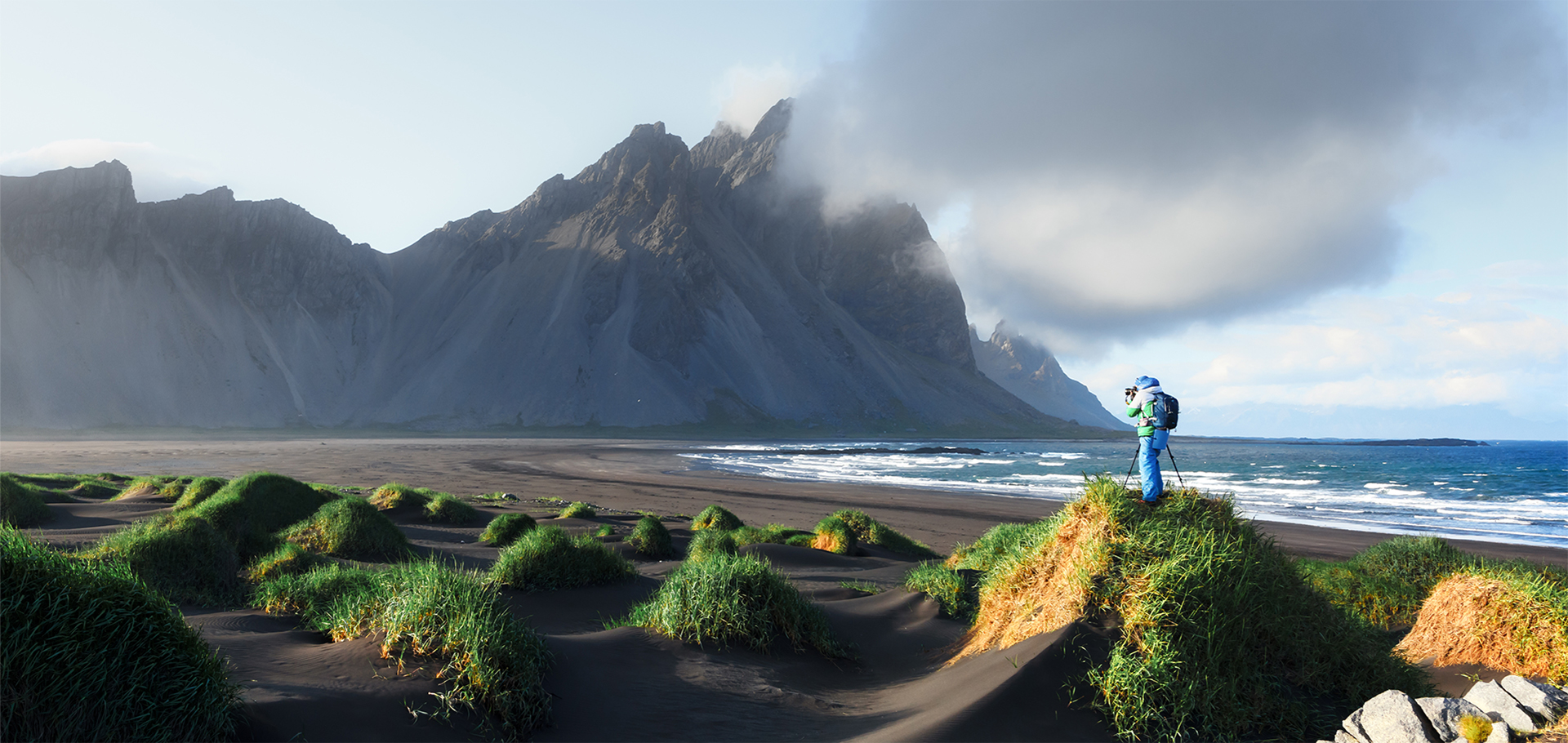
Everywhere you look in Iceland, there is evidence of the dramatic interaction between fire and ice. This couple stands atop a tuya overlooking a valley that has seen hundreds of glacial outburst floods. If they scoured the ground around them, they might even find fragments of volcanic glass or pieces of pumice.

© Eddy Savage


