


2027 Itinerary
On most days, we will rise later in the morning and stay out very late, to capitalize on the often ethereal evening light (and fewer people about). Since Iceland lies near the Arctic Circle, summer days are very long, and it doesn't get truly dark in high summer. The light can be magic, and we plan our long days to take advantage of it.
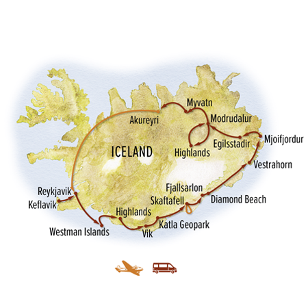
Arrive at Keflavik International Airport where you are met on arrival and transferred to our hotel in Reykjavik, about a 45-minute drive. If you arrive early, you may store your bags at our conveniently located hotel while you explore this compact, walkable city on your own. This evening, join our Expedition Leader for a welcome dinner at a local restaurant, with an orientation to all the photography adventures that lie ahead in this geological wonderland.
Depart late this morning for a rare inclusion on any Iceland itinerary: the remote Westman Islands. From Landeyjahofn, we make the 45-minute crossing to the main island of Heimaey. The Westman Islands—Vestmannaeyjar in Icelandic—were formed between 10,000 and 20,000 years ago from submarine eruptions. The land here remains very young, active and dynamic, shaped afresh with the 1973 eruption of Eldfell volcano that forced the entire Westman population to evacuate to the mainland via the islands’ fishing fleet. Heimaey was covered in ash and lava as the eruption continued for months, but eventually the stalwart islanders returned to dig out their homes and settle anew. After lunch on arrival, we board a sturdy high-speed RIB (rigid inflatable boat) for a 2-hour marine photo safari, cruising to several remote islands to view colonies of northern gannets, Atlantic puffins, black guillemots, common murres and more. The northern gannet population is among the largest in the world, with 1-2% of global numbers—some 26,000 breeding pairs— nesting in the Westmans. They thrive, along with other seabirds, due to a lack of predators on the islands—most notably Arctic fox. Coastal walks offer more views of puffins and rugged volcanic scenery. After dinner, return to the mainland by ferry and check in to our hotel late this evening, where we spend the next two nights.
Today’s journey takes us deep into Iceland’s remote Highlands. Traveling in Nat Hab's customized 4x4 mini bus with giant all-terrain tires, we traverse a colorful and otherwordly landscape. Rugged peaks in an array of shapes, forms and hues flank the primitive tracks we follow, the rock palette tinted by rhyolite and obsidian. A vivid blanket of gold and green alpine moss and lichen adds a bright accent, while black sand expanses lend contrast, filling the gaps between jagged ridges, volcanic summits and dramatic canyons and valleys. At times, the stark setting is evocative of a moonscape. The region is laced with braided riverbeds, which we cross multiple times. We spend the day making short photo stops and taking several walks for optimal vantage points.
Our main focus is the Landmannalaugur region. Located on the edge of the Laugahraun lava field formed by an eruption in the late 15th century, the area is renowned for its unique geology, including vibrant, multicolored mountains, obsidian caves and geothermal hot springs. The scale of the landscape is astounding, with stark ranges rising high above glacier-carved river valleys, volcanic craters and fields of lava covered in lime-green moss.
Please note: Weather will dictate our exact plans today. If conditions are better in the Fjallabak region of the highlands, we will explore Fjallabak Nature Reserve. A view of Myrdalsjokull glacier—one of Iceland’s largest, which conceals Katla, one of its most active volcanoes—is a highlight in this little-visited area.
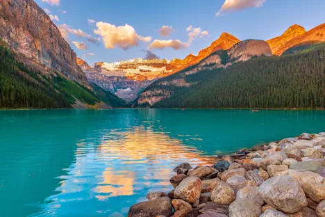
The South Coast is known for some of Iceland’s most spectacular waterfalls, and this morning offers a chance to photograph three of the largest and most famous: Seljalandsfoss, Skogafoss, and Kvernufoss. We’ll spend some time in the area around Vik, known for its volcanic black sand beaches and dramatic rock formations including Reynisdrangar Rocks. Legend holds that this trio of columnar basalt sea stacks was formed after two trolls were out fishing in a three-masted ship. When the trolls did not return to their cave before sunrise, they and their vessel turned into needles of stone, since trolls cannot tolerate daylight.
Continuing our encounters with the fascinating geological features on Iceland’s south coast, we investigate the dynamic relationship between fire and ice, examining the largest glacial outwash plane in the world. Katla UNESCO Global Geopark contains roughly 9% of Iceland’s total landmass, encompassing massive glaciers and active volcanoes that have shaped the land for millennia, including the powerful eruptions of Eyjafjallajokull in 2010 and Grimsvotn in 2011. The geopark also holds glacial rivers, lakes, meadows of purple lupine, black sand beaches, vast lava fields and caverns. We’ll get glimpses of outlet glaciers flowing down from the Vatnajokull ice cap, and Lomagnupur Mountain is also an impressive subject, with steep cliffs and a flat top that we may find reflected in nearby ponds.
Get a stunning aerial perspective on some of Iceland's most dramatic scenery from a 2-hour private fixed-wing plane flight over the Skaftafell region of Vatnajokull National Park. Known for its rugged landscapes, stark mountains and vast braided rivers, Skaftafell contains about half of the Vatnajokull Glacier, Europe’s largest ice cap. No roads penetrate the park’s wild recesses, but our extended low-altitude flight reveals aerial shots of Landmannalauger—a truly spectacular sight—amid an artistic landscape of intriguing patterns, contrasts and colors. Photograph the plain of Skeidararsandur (the largest glacial outwash plain on the planet), an expanse of black sand and ash sliced by braided glacial rivers that resemble an intricate network of veins. Other highlights include striking shots Maelifell with braided riverbeds wrapping around the lonely green mountain, the Laki volcano crater row, a 15-mile-long fissure in the highlands that erupted in 1783, creating a chain of 130 craters, and the jagged expanse of Skeidararjokull Glacier. This glacier drains off Vatnajokull, Iceland’s largest ice cap.
We also spend time on the ground, walking around the scenic outflow of Svinasfell Glacier, a large outlet glacier of the Vatnajokull ice field. Its surface is especially jagged, with many sharp ridges that lend drama to images, as well as its varied coloration—deep blue ice, white snow and veins of black ash left over from volcanic eruptions in centuries past. The ash patterns create remarkable abstract designs in the ice, a phenomenon not readily found anywhere else in the world.
After dinner, head to Diamond Beach, where icebergs wash up on shore to create a sparkling contrast with the volcanic black sand. The late evening light offers excellent photography conditions, with the sun’s sinking rays gleaming on the scattered icebergs, littered on the beach like chunks of glass. Seals also frequent the beach, and humpback whales are sometimes visible offshore.
On a private Zodiac cruise at Fjallsarlon Glacier Lagoon, we have extended time to photograph the glittering icebergs floating atop the meltwater lake. The lagoon is fed by the massive Vatnajokull Glacier, the largest in Europe. The ice cap covers more than 3,100 square miles—8% of Iceland—and the glacial tongues that flow from it calve the huge chunks of blue ice that litter the surface of the lagoons, drifting like a flotilla of whimsically shaped ships. We spend the remainder of the day exploring this exceptionally scenic region, stopping for striking shots of black sand beaches and rugged mountains as we follow the coast and hike hidden trails among terminal moraines, the end point of glaciers fed by the ice cap. Our exact itinerary is guided by weather and light, as we chase the best of both.
Today marks a transition in our itinerary, moving from Iceland’s youngest and most dynamic landscapes along the active rift zone toward older regions along the east coast. Along our eastward route, we seek out Icelandic horses, intricate riverbeds and more rugged landscapes to photograph. The Stokksnes Peninsula is full of enticing subjects, from beaches of jet-black sand to 10-foot-high sand dunes covered in bright green beach grass, and the ragged profile of Vestrahorn, one of Iceland’s most stark and distinctive mountains. The sheer-sided massif is comprised mostly of rare gabbro rock, a plutonic magma nearly 11 million years old. We also photograph the jagged range of Eystrahorn, a lesser-known set of peaks surveying a wild black sand beach on the southeast corner of Iceland. Then follow the coast into the little-visited East Fjords, which has some of the oldest rock in Iceland, with layer upon layer of basalt from ancient eruptions slowly carved away by 2.5 million years of successive ice ages. The expansive coastal plain transitions to classic U-shaped glacial valleys flanked by weathered basalt mountains. The ocean is always close as the road winds along the fjord-riven coast, unveiling rocky coves and picturesque fishing villages. After dinner in Breiddalsvik, capitalize on the evening light as we meander our way through the peaceful, less-traveled Breiddalur Valley, with stops along the way to photograph burbling creeks, lakes and striking mountains. A short walk leads to Flogufoss, a hidden waterfall deep in the valley. Then, we drive across a mountain pass and drop into the glacial valley of Lagarfljot, continuing to Egilsstadir, East Iceland’s largest town, where we spend two nights.
Travel inlandfrom Egilsstadir for an in-depth exploration of scenic Lagarflojt Valley, including a photo stop at Lagarflojt Lake, where local lore holds that a sea monster inhabits its waters. We are surrounded by awild, rural landscape, and a visit to a farm in this evocative setting offers a private opportunity to photograph Icelandic horses.
Continue to Borgarfjordur Eystri, a fjord that is reputedly home to one of numerous “elfin communities” that thrive in Icelandic mythology. The fjord takes its name from the Icelandic elf-queen, Alfaborg, who is said to live nearby. Here we find one of Iceland’s largest Atlantic puffin colonies, and we spend several hours among them this afternoon on a puffin photography intensive. A boardwalk weaving through the colony allows easy access, and since the puffins are accustomed to human presence, we are able to get exceptionally close shots. Return to Egilsstadir for a second night.
Our focus for the first half of the day is one of the most photogenic of the East Fjords, the slender finger of Mjoifjordur, which means "narrow fjord." Carved out by successive ice ages and protected from the elements along the outer coast, the water is often calm as glass, making for beautiful reflection photography. We occasionally spot whales in the fjord as well. This is one of the most remote destinations in Iceland, accessed by a road that is open for only about four months a year, when it is snow-free. The steep, winding gravel road that descends to the sea extends to the end of the 11-mile fjord. Mjoifjordur’s setting at the head of the fjord is stunning, surrounded by an amphitheater of waterfalls. A highlight is Klifbrekkufossar, a seven-step cascade that terraces down through a rugged chasm carpeted with green vegetation. A trail hugs the side of the waterfall, allowing access to varied angles and closer views. Climbing into the highlands, we follow Iceland's original Highway 1 over two remote passes to reach Modrudalur. This is one of the oldest farms in Iceland, with evidence of its presence since the original settlement by the Vikings. The site was an important crossroads where two historic cross-country trails intersected, and its location is referenced in the famous Sagas that date to the 10th and 11th centuries. Modrudalur is also the highest inhabited place in Iceland, at 1,539 feet above sea level. We spend the next two nights here at Fjalladyrd, a hospitable family-run farm.
Set out in our custom 4x4 vehicles to explore more of the hidden wonders of Iceland’s little-visited Highlands. These rugged high-suspension mini buses have been modified with big tires and extra shock absorption to provide a more comfortable ride over off-road terrain, allowing deeper access into this remote region. On our adventurous journey through the lunar-like landscape, we make multiple stops to photograph impressive landmarks that may include 5,501-foot Herdubrid, a peak known as the “Queen of Iceland.” Plant life grows where water flows, craters pock the terrain, and old lava flows from the active Askja volcanic system create an wondrous landscape. Marvel at Hafrahvammagljufur Canyon, a dramatic gorge more than 650 feet deep, from high grassy slopes overlooking the chasm. We also visit one of Iceland’s traditional turf houses—historic dwellings constructed from earth, stone and timber. Return to Modrudalur for a second night at Fjalladyrd.
Photograph mighty Dettifoss, Europe’s largest waterfall by volume and the most powerful in Iceland. This thundering curtain of water, spanning 330 feet and churning spray into the sky, is fed by the giant Vatnajokull Glacier, which spawns the Jokulsa a Fjollum River, the second-longest in Iceland. Dettifoss is contained inside a massive canyon carved out by ancient glacial outwash floods, where four times the volume of the Amazon River once tore through this landscape. We frequently see rainbows over the falls, which make for dramatic photos. We also stop at Selfoss, a striking U-shaped wall of rushing cataracts fed by the same river originating in Vatnajokull.
Continue to Lake Myvatn, located in the rift zone of the North American and Eurasian tectonic plates. The lake was formed during a massive eruption 2,300 years ago and is still a site of geothermal activity, with lava flows coming most recently from the 1984 eruption of Krafla volcano. Numerous lava formations are found in and around the shallow lake, and we photograph the pseudocraters of Skutustadir on a short hike. These phenomena are formed when lava flows over wet ground, pushing it down and trapping steam. As pressure mounts, steam explosions create these fascinating "false craters." One of the premier birdwatching areas in the world, Lake Myvatn’s marshes provide habitat for huge numbers of migratory birds in summer. More than 115 species have been logged here, including 15 species of nesting ducks, horned grebe, great northern diver, common loon, red-throated loon, whooper swan, Barrow's goldeneye, and many more seasonal visitors.
Nearby, we photograph the striking turquoise lake that fills Krafla Viti Crater. More of Iceland's simmering subterranean energy is on display at Hverarond, hissing with steam vents, bubbling mud pots and pungent sulphur. Driving west, we photograph Godafoss, one of Iceland’s most beautiful waterfalls, which originates deep in the highlands. Shaped like a crescent, it drops 40 feet over a sheer volcanic cliff. Ultimately, we arrive in Akureyri for a farewell dinner before our evening flight back to Reykjavik.
A transfer is included from our hotel in Reykjavik to Keflavik International Airport—about a 45-minute drive—to meet departing flights.


