
By Nat Hab Expedition Leader Eddy Savage
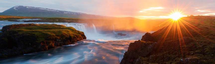
Iceland is home to some of the most spectacular and photogenic waterfalls in the world. These waterfalls don’t necessarily have huge amounts of water flowing over them, but the rugged and unique landscape surrounding them adds to their charm and beauty. The diversity of new and old volcanic landforms provides for an exceptional array of waterfalls. Iceland is very young geologically speaking, and the entire island was built by 14 to 16 million years of successive above-water volcanic lava flows. Iceland is splitting apart along the mid-Atlantic ridge rift zone, which is situated in the middle of the island. As it pulls apart, about an inch per year, it leaves the oldest land to the east and west of the country and the youngest land in the middle. The rift zone is where we can find Iceland’s active volcanic systems and new lava flows, or new land. In the Eastfjords and Westfjords, the bedrock is between 10 million and 16 million years old. The different age zones of the island provide for exceptionally different-looking waterfalls.
The Rift Zone Waterfalls

Kvernufoss
The Pleistocene, or Ice Ages, started approximately 2.5 million years ago, staying for 100,000 years, thawing for 20,000 years, and then repeating this cycle since that time. Iceland’s landscape has been distinctly affected by the repeated visitation of ice sheets. Volcanic eruptions underneath the ice sheet (which could have been 1 mile thick in some places), created distinct landforms. When a volcanic eruption occurs under an ice sheet, the heat from the lava interacting with the cold ice creates an incredibly strong, pressured and explosive eruption. This can trigger a glacial outwash flood that often attains flow equal to the largest rivers in the world for a short period of time. The burst of water finds its way down to the sea and erodes the land in its way.

Peering out from behind Seljalandsfoss © Eddy Savage
Concurrently, the lava cools exceptionally fast, and ash and other debris have nowhere to go as it is being trapped by an extremely vast and heavy load of ice. During the eruptions, layer upon layer of igneous breccia (small rock fragments), hyaloclastite (compacted ash and other fine particles), and basalt lava flows accumulate to create tuya mountains (table mountains) and Moberg ridges (hyaloclastite ridges). We will call it “igneous sedimentary rock” for the purpose of this article.
You can only find these “igneous sedimentary rock” areas within the younger areas of Iceland. The land must be less than 2.5 million years old and have been covered in ice during the eruption phase for these formations to appear. The south of Iceland has some iconic waterfalls that carve their way through this terrain.
Three south coast gems—Seljalandsfoss, Kvernufoss and Skogafoss—share an interesting feature: They fall about 200 feet off an “igneous sedimentary rock” cliff.

Travelers ride horseback toward Skogafoss © Eddy Savage
When ice was covering the region, the immense weight of the mile-thick ice sheet depressed the island down (like pushing on a memory foam pillow) so that the ancient shoreline would have been around 150-200 feet higher (or the land 150-200 feet lower) than today. When the ice melted, crustal rebound began and, with the weight of ice gone, the cliffs lifted back up 150-200 feet.
The cliffs that these three iconic waterfalls topple over were an ancient seawall where, for millennia, the ocean would have crashed against and easily eroded the “igneous sedimentary rock” wall. Because this “igneous sedimentary rock” is softer than most other volcanic rock in Iceland, the ocean ate away at the coast and left behind dramatic canyons, cliffs and caves along an ancient shoreline spanning many miles along the southern edge of Iceland.
The Waterfalls of the Eastfjords and Westfjords

Dynjandi waterfall in the Westfjords
As we move to the east and west of Iceland, we head towards the older areas of Iceland. The mountains of the east and west have had a different effect from the 2.5 million years of ice ages. The land is comprised of layer upon layer of basalt lava flow intermixed with intrusive dykes (from fissures where an eruption occurred). This landscape begins to look more like a purposefully carved layer cake than the rugged and crumbling rifting areas. The ice sheets carved vast u-shaped valleys into the hard basalt with their repeated growing and melting. Like a bulldozer, the heavy ice powerfully crushes, plucks and plows through even the hardest of rocks. Much of the hard work in shaping the land has already been done by the ice sheets, and the waterfalls don’t have too much sway in re-shaping the hardened basalt rock landscape. Instead of carving deep troughs or canyons, the waterfalls here powerfully crash their way over rugged and jagged mountainsides of stratified basalt, finding ancient fissures in the rock to lead their way down to the ocean.
Folaldafoss in East Iceland is a great example of this. Above the waterfall, you can see the stratification layers of basalt. To the left of the waterfall, you can see an intrusive dyke that would have filled an ancient fissure with lava and made a natural course for water to flow.

Folaldafoss waterfall
Möngufoss in the Westfjords is another great example of this. It carries even more evidence of the past ice ages wreaking erosive havoc on the basalt lava flows. The watershed for Möngufoss is in a hanging valley. The ice-age glacier that sat in this u-shaped valley above the falls would have fed into a larger glacier below. The height of the larger glacier would have been roughly the same as the valley floor, allowing the upper, smaller glacier to flow easily into it without carving the valley much lower. As the ice age ended and the glaciers retreated, the larger glacier left the fjord below, and the smaller glacier valley above was left “hanging,” hence the term “hanging valley.”

Baejarfoss, Westfjords
Waterfalls are only a small piece of the experience of Iceland, but they are endlessly fascinating. The dynamic way in which Iceland was formed and is still forming ensures that around every corner there will be something new to see. In my opinion, time spent enjoying, exploring and photographing these waterfalls is a highlight of our Iceland expeditions. I look forward to seeing you over there!

© Eddy Savage


